Get in touch with QJKH Company
2D LiDAR Sensor — Precision Scanning Solutions for Industrial Automation | CCH
CCH 2D LiDAR sensors are capable of millimeter accuracy across a scan field as wide as 360 (omnidirectional) and as narrow as 45, optimized for applications such as AGV navigation, perimeter security, and industrial safety, where failure is not an option.
Scanning Range
0.1 – 200 m
Field of View
Up to 360°
Angular Resolution
Down to 0.036°
Scan Frequency
Up to 50 Hz
IP Rating
IP65 / IP67
Interface
Ethernet / Serial
Why Your Automation Project Needs a High-Performance 2D LiDAR Sensor
If your AGV suddenly stops mid-operation, your perimeter detection zones are setting off when they shouldn’t, or your measurement systems are drifting out of tolerance, the first place to look is the sensor layer. 2D LiDAR sensors fire hundred to thousand narrow laser pulses across a single scanning plane, recording Time-of-Flight return signals or triangulation angles to create a high-resolution distance profile of the scene. It updates this profile up to 100Hz at a millimeter level of repeatability – and unlike ultrasound and infrared sensors, it works in any lighting or environmental scenario.
All proximity sensor technologies have hard limitations that multiply as project scope does. The detection range of ultrasonic sensors is limited to a handful of meters and the cone angles are wide enough to interpret a forklift as a wall. IR sensors are affected by changing lights, dust, dirty optics, and reflective surfaces. Both technologies generate blind zones, where no data exists and no obstacle can be identified, forcing engineers into multiple sensor arrays, added complexity, and calibration efforts.
A 2D LiDAR replaces all those sensors with a single unit translating laser impulses on a 45-360 spread and reading return signals from 0.1-200m, based on model series. The laser operates at Class1 eye-safe wavelengths (usually 850-905nm) as described in IEC60825-1, so the sensor is not restricted to any room safety procedures. IP67-rated bodies keep humidity, dust, and water from penetrating the sensor bodies, per IEC60529, so the sensor can run along on wash-down lines.
One common theme among us in the field: integrators plant 2D LiDAR at their sensor base and flow additional cameras or IMUs onto the sensor stack for edge case handling. In the words of one robotics specialist,
“Sensor fusion is a requirement – 2D LiDAR is the stable geometric base.”
That’s because range data from LiDAR is absolute, uninfluenced by lighting, surface color, or temperature. While cameras offer detailed contextual data, they lack reliable depth accuracy. IMUs provide motion context but drift over time, with the 2D LiDAR providing an absolute, dependable geometric reference. That foundation begins with finding the right sensor for your detection distance, speed of operation, and environmental conditions.
CCH 2D LiDAR Product Line — Models, Specs, and Selection Guide
Our 2D LiDAR sensors come in three series, each optimized for a discrete detection range and application needs. We don’t offer just one sensor that fits as many jobs as possible – because there are applications that scan as close as 3m like warehouse AGV pathways and those that have to scan as far as 150m like outdoor industry perimeters.
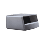
Short Range CCH-LS Series
Range: 0.1 – 12 m
FOV: 270°
Angular Res: 0.36°
Scan Rate: 15 Hz
IP Rating: IP65
Interface: UART / USB
Best For: Indoor AGV, collision avoidance, shelf scanning
Mid Range CCH-LM Series
Range: 0.1 – 40 m
FOV: 360°
Angular Res: 0.18°
Scan Rate: 25 Hz
IP Rating: IP67
Interface: Ethernet / UART
Best For: SLAM navigation, warehouse logistics, zone monitoring
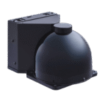
Long Range CCH-LN Series
Range: 0.1 – 200 m
FOV: 360°
Angular Res: 0.036°
Scan Rate: 50 Hz
IP Rating: IP67
Interface: Ethernet (TCP/UDP)
Best For: Perimeter security, crane avoidance, traffic systems
Spec Comparison Table
| Parameter | CCH-LS Series | CCH-LM Series | CCH-LN Series |
|---|---|---|---|
| Detection Range | 0.1 – 12 m | 0.1 – 40 m | 0.1 – 200 m |
| Field of View | 270° | 360° | 360° |
| Angular Resolution | 0.36° | 0.18° | 0.036° |
| Scan Frequency | 15 Hz | 25 Hz | 50 Hz |
| Sampling Rate | 8 kHz | 32 kHz | 100 kHz |
| Sensing Method | Triangulation | ToF | ToF + Multi-Echo |
| IP Rating | IP65 | IP67 | IP67 |
| Interface | UART / USB | Ethernet / UART | Ethernet (TCP/UDP) |
| Operating Temp | -10°C to +50°C | -25°C to +50°C | -30°C to +60°C |
| Laser Class | Class 1 (IEC 60825-1) | Class 1 (IEC 60825-1) | Class 1 (IEC 60825-1) |
Application Decision Matrix
| Application | Minimum Range | Min Angular Res | Min Scan Rate | IP Requirement | Recommended Series |
|---|---|---|---|---|---|
| AGV Navigation | ≥ 12 m | ≤ 0.36° | ≥ 15 Hz | IP65+ | CCH-LS / CCH-LM |
| Perimeter Security | ≥ 80 m | ≤ 0.1° | ≥ 25 Hz | IP67 | CCH-LN |
| Industrial Measurement | ≥ 20 m | ≤ 0.18° | ≥ 20 Hz | IP65+ | CCH-LM |
| Warehouse Logistics | ≥ 8 m | ≤ 0.36° | ≥ 15 Hz | IP65+ | CCH-LS / CCH-LM |
| Crane Collision Avoidance | ≥ 100 m | ≤ 0.1° | ≥ 30 Hz | IP67 | CCH-LN |
2D LiDAR vs 3D LiDAR — Which Technology Fits Your Application?
The 2D vs 3D decision dictates your entire program budget, processing system architecture, and rollout schedule. While both types rely on laser-based ranging, they are meant to solve unique problems—and the cost differential is not small.
| Dimension | 2D LiDAR | 3D LiDAR |
|---|---|---|
| Scanning Plane | Single plane (horizontal or tilted) | Multi-plane or full hemisphere |
| Detection Range | 0.1 – 200 m (model dependent) | 0.3 – 300 m typical |
| Angular Resolution | 0.036° – 1.0° | 0.1° – 0.4° (vertical + horizontal) |
| Data Output | 2D point array (distance + angle) | 3D point cloud (x, y, z per point) |
| Processing Load | Embedded MCU capable | Requires GPU or dedicated SoC |
| Power Consumption | 2 – 8 W typical | 8 – 30 W typical |
| Unit Cost Range | Lower tier | 3× – 10× of equivalent 2D unit |
| Typical Applications | AGV safety, SLAM, perimeter, profiling | Autonomous driving, terrain mapping, complex object recognition |
When to Choose 2D LiDAR
Choose 2D if your detection problem is restricted to a known plane: ground-floor obstacle detection for AGVs, horizontal zone containment for perimeters security, height profiling for logistics sorting. The processing chain remains manageable by a simple embedded board and one 2D unit can often replace whole arrays of point sensors.
When 3D Is Necessary
Extra cost of 3D LIDAR is justified where the solution demands occupancy awareness: shape detection and classification of pedestrians versus objects, detailed mapping of unstructured terrain. Autonomous vehicles, drone survey, robotic bin-picking are typical use cases. If you application doesn’t need height differentiation or object recognition, 3D is an expensive distraction.
TCO Perspective
2D LIDAR affords a cost advantage of over 50% net of sensor plus processing cost when compared to full 3D data collection and processing. When deploying a fleet of such LIDARs this differential translates into a huge savings in upfront capital, installation complexity, and time to deployment.
Ready to determine which technology fits your project?
Request a Custom Comparison →How to Choose the Right 2D LiDAR — ToF, Triangulation, and Hybrid Methods
Sensor technology inside a 2D LIDAR is the most impactful parameter you will choose. It defines your maximum sensing range, resolution of sensing points, maximum scanning rate, and price point. Three techniques dominate the industrial marketplace, all delivering distinct benefits and limitations.
| Parameter | Triangulation | Time-of-Flight (ToF) | Hybrid (ToF + Multi-Echo) |
|---|---|---|---|
| Sampling Rate | < 20 kHz | Up to 100 kHz | Up to 100 kHz |
| Frame Rate | < 20 Hz | 30 – 50 Hz | 30 – 50 Hz |
| Effective Range | 0.1 – 10 m | 0.1 – 200 m | 0.1 – 200 m |
| Accuracy | Sub-mm at short range | cm-level, consistent at distance | cm-level, filtered noise |
| Ambient Light Resistance | Low (affected by sunlight) | Moderate | High (echo discrimination) |
| Multi-Target Capability | Single return | Single return | Multiple returns per pulse |
| Environmental Protection | IP54 – IP65 | IP65 – IP67 | IP67 |
| Relative Cost | Lowest | Mid-range | Premium |
Triangulation: Precision at Close Range
Triangulation sensors work by projecting a laser beam at the target, and then measuring the angle between the incident beam and the detected reflection. (A position-sensitive detector is used to find the reflection angle.) This geometry produces millimeter resolution measurements in a few meters’ range, making it the go-to methodology for 2D laser profilometry applications like quality inspection and surface scanning, or for gap measurements used in automated packaging systems. Triangulation range efficiency diminishes quickly towards the 10m mark, and direct sunglare saturates the sensor capable of measurements.
Time-of-Flight: Range Without Compromise
Time-of-flight sensors determine distances by calculating the interval during a laser pulse’ round trip, translating that interval from nanoseconds into meters and centimeters. The methodology enjoys an arching linear measurement profile out to hundreds of meters, with a constant resolution across the entire telemetry zone. Operating at speeds from 2kHz to well over 100kHz, this method offers dense sampling points, Rapid rate of data, effortless application of SLAM concepts and navigation.
Hybrid: Industrial-Grade Filtering
Hybrid systems mix ToF ranging with multiple return processing, sensing multiple bounce back waves of each laser pulse to discern rain, fog, mist and other suspended debris from transparent parts and other darker transparent surfaces. When a single pulse hits rainwater and then the solid object behind it, the sensor produces an accurate distance measurement rather than detecting the water drop that presents as a false first return. This processing approach is mandated in outdoor perimeter detection applications and for systems mounted on remotely operated cranes.
“We chose multi-echo ToF for our CCH-LN series precisely because false triggers induced by rain, sea spray, and airborne particulate are unacceptable to our customers in port automation and outdoor security applications. Single-echo ToF is suitable for clean indoor conditions; in industrial outdoor apps, the filtering layer is required.”
Industrial Applications — AGV Navigation, Perimeter Security, and Smart Logistics
LiDAR is a tool, and it’s only as good as the function you need it to perform. Every downward facing vertical has its own parameter needs, and using the wrong sensor for the application produces the same limitations and false triggers as you sought to avoid.
1. AGV/AMR Navigation and SLAM
Challenge
The mobile robot must perform real-time map building & localization especially in such dynamic and busy warehouse environments including but not limited to pallets, forklifts, etc.
LiDAR Solution
The sensor data is derived from a 360 2D LiDAR mounted at the height of the chassis. It supplies the first layer of information for the SLAM algorithms—range profiles every 25+ Hz for real-time map building. It also provides information about static infrastructure (for localization) and dynamic obstacles (for path replanning).
Key Parameters: Range: ≥ 12 m | Angular resolution: ≤ 0.36° | Scan rate: ≥ 15 Hz | FOV: 360°
2. Perimeter Security and Intrusion Detection
Challenge
Outdoors perimeter area false alarms from plants moving, animals, rain, changing light levels overuse the camera only and PIR systems.
LiDAR Solution
The long-range 2D LiDAR with multi-echo filtering enables establishment of configurable detection zones with specific distance thresholds for sensor detection of a person in a restricted zone vs. rain drops passing the beam. The zone alarm logic aims to minimize false-positives; alarms are based on object size and time thresholds.
Key Parameters: Range: ≥ 80 m | IP67 required | Ambient light: ≥ 80 klux | Multi-echo filtering: required
3. Crane Collision Avoidance
Challenge
Overhead and gantry cranes operate in dusty, heavily v.b rated regions of high vibration where collision occurrences can be fatal to both safety and financial considerations.
LiDAR Solution
The long-range 2D LiDAR installed near the top of the crane boom is used for collision avoidance. It will scan the travel path and identify obstacles a sufficient amount of time in advance for the automatically metered deceleration or stop commands. The Weatherproof IP67 plastic housing while operating in the temperature range -30C to +60 can survive the outdoor port and mill environments.
Key Parameters: Range: 100 m | scan rate: 30 Hz | Response time: 40 ms | operating temp: 30C to 60C
4. Warehouse and Logistics Automation
Challenge
High-throughput distribution centers require pallet detection, conveyor monitoring, and dynamic obstacle avoidance in environments with reflective shrink-wrap, glass, and mixed surface materials.
LiDAR Solution
Mid-range 2D LiDAR provides reliable detection of pallet positions and gaps between packages for automated stacking and retrieval. Multi-echo capability resolves reflections from transparent and semi-transparent packaging materials that confuse single-echo sensors.
Key Parameters: Range: ≥ 8 m | Angular resolution: ≤ 0.36° | Reflectivity handling: ≥ 10% target detection
5. Smart Traffic and Toll Systems
Challenge
Vehicle detection and classification at toll plazas and intersections demands reliable operation across all weather conditions, 24/7, with minimal maintenance.
LiDAR Solution
Overhead-mounted 2D LiDAR scans cross-sections of passing vehicles, measuring height profiles for vehicle classification (motorcycle, car, truck, oversized). The sensor’s millimeter resolution at highway-speed scan rates delivers consistent classification accuracy independent of lighting conditions.
Key Parameters: Range: 20 M |Scan rate:50 Hz |Angular resolution:0.18 |IP67 required
Integration note: for reasonably complicated environment overlay of structure with many obstacles- warehouse with outdoor loading bays- blending camera+ IMU+ LiDAR capabilities expands ‘detection envelope’ further than either single sensor. Geometric ranging performance handled by single layer, camera as object classifier, IMU bridge in short-term absence of Geometric performance even from ToF. Its this layered approach that explains how modern AGV fleets keep safety critical certification while working with human workers.
Explore how CCH sensors integrate into your automation setup.
Request a Free Sample →Certifications, Quality Assurance, and Global Trust
Any purchasing department needs more than datasheet definitions; actual documented assurance that a sensor will pass incoming inspection at their factory. CCH holds the certifications that procurement engineers check first.
CE
FCC
RoHS
ISO 9001
Standards That Govern 2D LiDAR Deployment
IEC 60825-1:2014
Laser product safety. All CCHLiDAR sensors rated Class1, the highest safety class, which means zero hazard potential even with direct eye contact.
IEC 60529
Degrees of protection (IP code). IP67-rated CCH sensors are certified dust-tight (6) and safe for temporary water immersion at 1m height 30 mins (7).
ISO 13849
Machinery safety, safety of control circuit components. Works for LiDAR sensors in safety-related automation systems and AGV safety zones.
IEC 61496
Machinery safety, electro-sensitive protective equipment. For use with active opto-electronic machine protectors.
Manufacturing Quality Process
01
Incoming Inspection
02
Optical Assembly
03
72h Burn-In Testing
04
Calibration & Final QC
05
Packaging & Shipping
All sensors receive 3 days burn-in at thermal stress prior to calibration- an infants death detection step that defeats tests of this kind. Outgoing data is logged on a traceable serial number basis and can be supplied on demand.
Historical supply chain context: reports now are that the vast majority of LiDAR units worldwide are delivered by Chinese OEMs, reflecting the maturing of Chinese laser and optics manufacturing infrastructure in the last ten years. CCH offers 20+ years of industrial safety sensor operations into this field- our archive was laser safety scanners and bodily-protecting light curtains, products where failure causes death. That same engineering discipline applies directly to this product range.
Procurement Guide — Pricing, Lead Times, and OEM Customization
The cost of a 2D LiDAR depends on its detailed specifications and the project’s scope, rather than a published list price. To save time and money we don’t publish a tariff broad-brush- instead we price our TS based on the six parameters that most affect cost.
Six Dimensions That Drive 2D LiDAR Pricing
Sensing Technology
Those beginner-level triangulation units are the entry price point, non-ToF. For the best combination of feature set at a reasonable price (-ray) it’s best to look at the hybrid- ToF with multiple echoes option.
Detection Range Tier
Longer detection range requires larger laser power budgets, more sensitive detectors, precision optics. Moving from 12m class sensors to 200m class sensors is a significant cost step within this family of technology.
Scanning Frequency
Higher scan rates (15 Hz vs 50 Hz) require faster motor assemblies, higher-bandwidth data interfaces and more processing power to maneuver each of them, each of which results in added product cost.
IP Protection Level
IP65 enclosures use standard O-ring sealing. IP67 requires precision-machined enclosures, potted cable exits and further testing – incurred cost of material and labor per camera unit.
Interface Options
UART and USB interfaces use standard serial transceivers. Ethernet (TCP/UDP) require PHY chips, RJ45 connectors and protocol stack firmware. Industrial Ethernet protocols (EtherCAT, PROFINET) demand further license and hardware cost.
OEM Customization Scope
Standard catalog products shipped at list prices. Custom firmware (proprietary data protocols, zone logic), custom enclosure (form factor, material, branding) and custom interface configurations incur engineering charges that amortize across order volume.
Volume Pricing Structure
CCH offers tiered pricing across three volume bands: sample/evaluation quantities (1-5 units), project quantities (6-100 units), and production volumes (100+ units). Each tier represents different handling, testing and packaging workflows on our end. For production volume, we work with your purchasing department on blanket purchase agreements that lock in pricing – reducing each subsequent units delivered but delivering product on a predictable schedule.
Lead Times and Logistics
Lead times depend on order volume, customization scope and current production schedules. Contact our sales team for an estimated lead time specific to your order configuration. Standard catalog models typically ship faster than OEM-customized units.
Ordering Flexibility
MOQ
Flexible. We accept sample orders for evaluation – no minimum quantity required for initial testing.
Free Test Samples
Available for qualified projects. We ship evaluation units for use by your engineering department to validate performance against your actual operating environment prior to full-scale purchase.
OEM Customization
Custom firmware, enclosure design, interface protocol, cable assemblies and private-label branding. CCH has supplied OEM components to global automation brands for over twenty years.
Shipping
Complete global coverage via DDP, FOB or EXW. Direct delivery from our Hangzhou facility to your preferred destination.
Engineering & Decision Tools
To help you navigate the complexities of sensor selection and project planning, we have developed these interactive engineering tools. Evaluate your technology needs or calculate precise geometric coverage instantly.
2D vs 3D LiDAR Decision Tool
Evaluate your project requirements, processing budget, and environmental conditions to determine the exact LiDAR dimensionality your application demands.
Open Tool →LiDAR Scanning Coverage Calculator
Input your mounting height, detection distance, and angular resolution to calculate the precise geometric coverage and blind spots of your 2D LiDAR setup.
Open Calculator →Start Your 2D LiDAR Evaluation Today
OEM or single-sample access is just an email away. Our application engineers are ready to find the right sensor to meet your specifications.
FAQ — 2D LiDAR Sensor Buyer Questions
2D LiDAR pricing varies by sensing technology (triangulation, ToF or hybrid), detection range, scan frequency, IP protection level, and order size. Triangulation-based short-range units are lowest in cost, whereas long-range ToF units capable of multi-echo filtering are highest. Contact CCH for an application-specific quote – we provide costs based on application details.
2D LiDAR performs a single scan plane, providing high-speed distance profiles (angle + distance pairs) with minimal processing needs. 3D LiDAR scans multiple planes or a full sphere, offering volumetric point clouds that demand GPU-like processing. Select 2D for detection within a flat plane (AGV safety, perimeter monitoring, profiling), otherwise choose 3D for terrain or object detection.
AGV and automation applications need 360 FOV, 15Hz scan rate, and fine angular resolution for SLAM map building (.36). The CCH-LM Series is capable of this, with 40m range and 25Hz scanning. For basic reflector based navigation in pre-defined environments the CCH-L S Series offers a low-cost solution. Ask us for a free sample to evaluate with your nav stack.
Yes-if you choose the right model. For outdoor use the following upgraded features are needed: IP67 environmental protection, multi-echo filtering (to reject rain, fog and dust returns), extended temperature range and high ambient light tolerance (>80klux). The CCH-LN Series is designed for outdoor perimeter security or crane applications, with operating temperature -30C to +60C and fully sealed IP67 to IEC60529.
CCH LIAR sensors are CE, FCC and RoHS certifiec. All models are IEC60825-1:2014 Class1 eye-safer laser. IP67-rated models have IEC60529 certification. Our factory has ISO9001 quality management certification. Certificate-ready documentation can be provided for your procurement file.
Some test samples are available free of charge for qualified projects, with no purchase obligation. For OEM customers; CCH provides custom firmware, housing design, protocol interfaces, cable assemblys and OEM private label branding options. Having supplied OEM solutions to international automation brands for over 20 years, we have the production capacity to fill volume orders. Please contact us with your project needs.
Trending now